



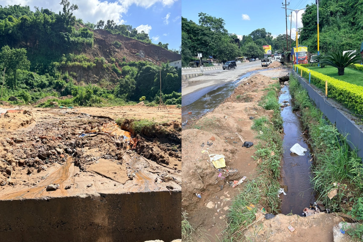
Repeated flooding at Jorabat raises questions over drainage failures, construction impact, and the future of a key Assam-Meghalaya gateway
For thousands of commuters, transporters and businesses passing through Jorabat every day, the biggest uncertainty during the monsoon is no longer the rain itself, it is whether the road will remain accessible.
ALSO READ: Who Speaks for the Voiceless? Guwahati's Beltola Dog Deaths Raise Questions on Animal Cruelty
Located along the Assam-Meghalaya border, Jorabat is one of the Northeast’s most important transport corridors, connecting Guwahati with Shillong and several districts of Assam and Meghalaya. The route serves as a vital link for passenger vehicles, commercial carriers and tourists travelling between the two states.
However, every monsoon, even a few hours of heavy rainfall can bring this vital gateway to a standstill. Vehicles get stranded in long queues, commuters lose hours on the road, muddy water enters nearby shops, and authorities are forced to divert traffic.
Despite the recurring disruptions year after year, residents and commuters say the fundamental problem remains unresolved.
A police official posted at Jorabat said waterlogging develops rapidly after prolonged rainfall, often disrupting traffic movement in the area.
"After one to two hours of incessant rainfall, waterlogging happens in this Jorabat area. During that time traffic also comes to a halt. Sometimes, when the waterlogging is severe, we need to divert the route. If the waterlogging happens during peak hours of vehicular movement, then the congestion remains for a longer period," the official said.
While confirming the repeated traffic disruptions, the official declined to comment on the reasons behind the flooding.
The impact, however, is visible every time heavy rain lashes the region. Long lines of vehicles build up along the interstate border, emergency movement becomes difficult, and commuters are forced to wait until water levels recede.
Residents and business owners in the area believe the problem goes beyond rainfall alone.
A shopkeeper from the 10th Mile area blamed clogged drains for the repeated flooding.
“The drains often remain clogged. Even if it rains for half an hour, this area gets submerged. I have never seen authorities cleaning these drains,” he said.
Another shopkeeper near the 8th Mile area raised concerns over the capacity of the existing drainage system, questioning whether it can handle the volume of water flowing down from the surrounding hills.
"These drains are not even six feet wide. They should be at least ten feet. When water flows from the mountains, how will these drains handle it? The road is at a lower level than the drain, so where will the water go?
Even today the drain is overflowing. The muddy water enters the nearby Ganesh Mandir, making life very difficult for us," he said.
Their concerns point towards two major issues; inadequate drainage capacity and poor maintenance of existing infrastructure.
Unlike many urban flooding spots, Jorabat’s location gives the problem a wider regional impact. Every day, commercial vehicles, tourist buses, passenger cars and goods carriers use the route to travel between Guwahati, Shillong and other parts of Meghalaya.
When the stretch floods, the consequences extend beyond the immediate locality. Businesses face transportation delays, office-goers are stranded, tourists experience longer travel times, and emergency services struggle to navigate through the congestion.
The recurring waterlogging has therefore evolved from a local civic issue into a regional mobility challenge affecting two neighbouring states.
With public concern growing, Meghalaya Chief Minister Conrad K. Sangma has acknowledged the recurring flooding and said the state government is examining possible causes.
According to Sangma, ongoing road construction could be one of the factors contributing to water accumulation.
“The land below the main flyover is now several feet lower because of the road construction. That structure is leading to water collecting there faster,” he said.
Sangma described the altered landscape as creating a “bowl-like” structure where rainwater accumulates more quickly during heavy showers. However, he said the government was conducting a detailed assessment before arriving at any conclusion.
The issue has also drawn attention from the Assam government. Chief Minister Himanta Biswa Sarma has warned that unchecked hill-cutting and development around Jorabat could increase surface runoff towards Guwahati, worsening urban flooding and landslide risks.
Addressing a press conference after reviewing the state's flood response, Sarma said the issue was already before the Supreme Court and would be argued based on the findings of a court-appointed empowered committee. He also cautioned that continued destruction of the surrounding hills could overwhelm any drainage system and even pose a growing risk to the Lokpriya Gopinath Bordoloi International Airport.
Appealing to the Meghalaya government to regulate development around Jorabat, Sarma warned that if the current trend continued, "Guwahati will become an unmanageable city." He added that he had discussed the matter with Meghalaya CM Sangma but acknowledged that Meghalaya also had its own development priorities.
Meanwhile, Sangma said the Meghalaya government was exploring both immediate and long-term measures to address the flooding.
"We are studying all aspects and looking at whatever measures we can put in," he said, adding that Deputy Commissioners are coordinating efforts on the ground.
He added that district administrations of both states were coordinating efforts to reduce inconvenience to commuters and improve flood management.
While authorities continue to examine the causes, the exact reason behind Jorabat’s recurring flooding remains officially undetermined.
Residents continue to highlight clogged and undersized drains, while the Meghalaya government has pointed to possible changes in land levels caused by construction activities. Without a comprehensive technical assessment, the contribution of each factor remains unclear.
What remains certain, however, is the impact on the public.
Every spell of heavy rain transforms one of the Northeast’s busiest transport corridors into a major bottleneck, disrupting the movement of thousands of commuters and commercial vehicles. Police personnel are forced to step in to regulate traffic, businesses face repeated interruptions, religious institutions are affected by overflowing muddy water, and commuters are left uncertain about how long a routine journey may take.
For those who travel through Jorabat route every day, the disruption has become a recurring monsoon challenge. The question is no longer whether flooding will occur during heavy rainfall, but whether authorities can find a lasting solution to prevent the next downpour from bringing the border gateway to another standstill.


