



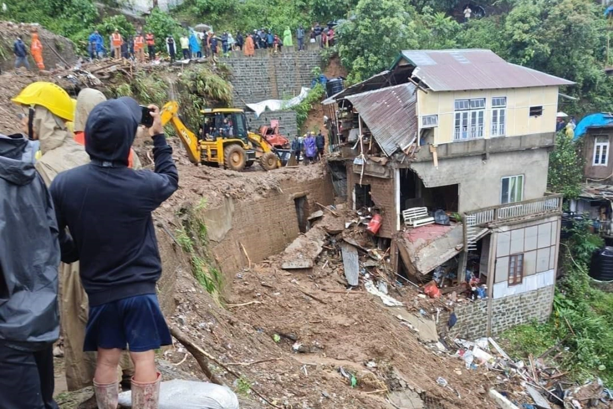
A string of landslides across Guwahati highlights the dangers of building on vulnerable hill slopes
For nine days in a row this July, the earth beneath Guwahati’s hills refused to hold.
ALSO READ: The Rivers We Forgot: How Neglected Tributaries Are Fueling Assam's Flood Crisis
A boulder tore through the bathroom wall of Ratan Das’s home off Bishnu Rabha Path on July 15. Four days later, a retaining wall collapse in Kharguli’s Beltola area sent mud crashing onto a homestay, crushing five parked two-wheelers and briefly cutting off traffic.
On July 19, another slope failure in Kharguli crushed at least six scooters, though no one was injured. The following evening, a hillside gave way at Madhabdev Nagar in Maligaon, trapping a family of four, railway employee Ranjit Das, his wife Sabitri, and their two children, beneath debris before rescue teams pulled them out.
On July 22, another stretch of red earth collapsed at Nizara Path in Kahilipara, sending mud onto the road in broad daylight.
Two days later, on July 24, a landslide along Upper Kuli Road in Khanapara, near the area’s first petrol pump, flattened a cattle shed, killing several cows and calves. Photographs from the site showed the tin roofing, wooden beams and bamboo framework of the structure reduced to rubble, while the hillside above bore a fresh scar of exposed red soil directly below an under-construction multi-storey building.
Residents blamed illegal mining on the hillside for weakening the slope, though authorities are yet to officially determine the cause. The exact extent of livestock loss has also not been independently verified.
Around ten landslides in less than two weeks are not isolated incidents in Guwahati. They highlight a recurring vulnerability in a city where rapid expansion continues to push construction into fragile hill terrain.
The Kamrup Metropolitan District Disaster Management Authority has identified 366 landslide-prone locations across the hills surrounding the city, covering areas such as Kharguli, Noonmati, Narengi, Khanapara, Maligaon and Kahilipara.
A detailed vulnerability assessment of 20 such localities found Kharguli to have the highest number of vulnerable sites at 77, followed by Noonmati with 40 and Narengi with 37. Nearly three-fourths of the surveyed locations, 74 percent were classified as requiring immediate intervention because of the risks they pose to life and property.
But Guwahati’s landslide vulnerability is not caused by rainfall alone.
The city lies along the Eastern Himalaya-Indo-Burma belt, a geologically active region characterised by weathered rock and loose, clay-rich soil. These conditions make many slopes naturally unstable, particularly when exposed to prolonged rainfall.
Studies on rainfall infiltration in Guwahati’s hill slopes have found that the soil formations are largely unsaturated residual deposits, meaning their stability depends heavily on how much moisture they absorb. During intense monsoon spells, increased water infiltration can significantly reduce slope strength.
The recent vulnerability assessment also highlights the impact of environmental degradation. Around 45 percent of the surveyed slopes have no vegetation cover, only 19 percent retain adequate tree cover to help bind soil, and 34 percent consist entirely of loose soil rather than rock.
However, officials and residents repeatedly point to another major factor, human interference.
The assessment of 399 vulnerable sites concluded that unplanned construction, slope cutting, encroachment and other human activities are significant contributors to slope instability in Guwahati.
A Guwahati Municipal Corporation official, responding to the Kharguli landslide that damaged several scooters, said construction on vulnerable hill slopes during the monsoon should be avoided and that responsibility for the incident was being examined.
The concerns are also reflected in Guwahati’s civic planning documents. The city’s Master Plan acknowledges that soil erosion on the hills is not merely an environmental issue but is connected to waterlogging, flash floods, declining groundwater levels and rising dust pollution.
It recommends preventing tree felling and encroachment while promoting large-scale afforestation, measures that have been discussed for years but have struggled to translate into sustained action on the ground.
This July’s series of landslides came amid a period of intense rainfall across Assam. The India Meteorological Department issued repeated forecasts 6 to 12 centimetres of heavy rain spells through the latter half of the month, while the Assam State Disaster Management Authority advised residents in hillside and low-lying areas to remain cautious and watch for signs of slope instability.
Assam’s flood and landslide-related death toll had crossed 47 by July 23, according to disaster officials, as several districts faced severe impacts from the monsoon.
For now, Guwahati has escaped fatalities in this latest wave of landslides, a situation officials and residents describe more as fortunate timing than evidence of preparedness.
At Bishnu Rabha Path, a fire safety vehicle sent after the boulder collapse could not reach the affected house because the access lane was too narrow. The incident highlighted a wider challenge: emergency response infrastructure in many hill localities has not kept pace with the dense settlements that have grown across vulnerable terrain.
The solutions repeatedly recommended by experts and officials are familiar: restrict construction on identified vulnerable slopes, relocate residents from the highest-risk zones where necessary, restore vegetation cover and improve drainage systems that channel water into already unstable soil.
The hills around Guwahati have been sending warnings for years. This monsoon, they are sending them more frequently.
The question is whether the city will respond before those warnings become something far more devastating.


